
The Rochford Mineral Exploratory Drilling Project (not the former Rochford gold project, now called the Bella project) would involve exploration drilling for graphite, a mineral that is used for electric vehicle batteries, lubricants, other industrial purposes – and for pencils.
The drilling has been proposed by Pete Lien & Sons, a Rapid City company known locally for its large gravel pit in the west part of Rapid City, the resulting poor air quality, and an iron ore mine at Nemo.
Why is this troubling – even more troubling than some of the other projects we’ve opposed? Because it is immediately adjacent to – and some proposed drill pads might be at – Pe’sla. Pe’ sla is a sacred site or homeland to which Lakota people return ceremonially multiple times throughout the year.
Click HERE for Plan of Operations.
4/2/26 UPDATE
On February 27, 2026, the Black Hills National Forest decided that a company should be allowed to drill for graphite without complete environmental review at Pe’sla. Pe’sla provides drinking water to Rapid City and is a sacred landscape at the heart of the Black Hills.

Pete Lien & Sons’ proposed Rochford Mineral Exploratory Drilling Project and any resulting mining risk contaminating our drinking water. Located in an essential supply zone within the Rapid Creek Watershed, the project endangers the water supply for Rapid City, Ellsworth Air Force Base, nearby communities, and reservation and ranch lands along the Cheyenne River. Graphite activity can contaminate water sources with sediments, heavy metals, and chemicals.
Pe’sla is also a place of ceremony — and has been for thousands of years. Pete Lien and Sons’ graphite project violates the constitutional treaty rights and religious freedoms of Indigenous peoples. This area is widely recognized for its religious and cultural importance, and some of the area has already been placed in trust to safeguard it from damaging mining activities, such as those proposed by Pete Lien & Sons.
Immediate Call to Action: Contact the US Forest Service’s Mystic District at (605) 343-1567 and request the reversal of the Pe’sla drilling decision. Say that you oppose letting the exploratory drilling project go forward without a complete environmental study.
2/27/26 UPDATE
URGENT NOTICE: The Graphite exploratory drilling project at Pe’Sla has just been APPROVED by the Black Hills National Forest.
Breaking News, February 27th, 2026. The Black Hills National Forest decided today that a company should be allowed to drill for graphite without complete environmental review at Pe’sla. Pe’sla provides drinking water to Rapid City and is a sacred landscape at the heart of the Black Hills.
Pete Lien & Sons’ proposed Rochford Mineral Exploratory Drilling Project and any resulting mining risk contaminating our drinking water. Located in an essential supply zone within the Rapid Creek Watershed, the project endangers the water supply for Rapid City, Ellsworth Air Force Base, nearby communities, and reservation and ranch lands along the Cheyenne River. Graphite activity can contaminate water sources with sediments, heavy metals, and chemicals.
Pe’sla is also a place of ceremony — and has been for thousands of years. Pete Lien and Sons’ graphite project violates the constitutional treaty rights and religious freedoms of Indigenous peoples. This area is widely recognized for its religious and cultural importance, and some of the area has already been placed in trust to safeguard it from damaging mining activities, such as those proposed by Pete Lien & Sons.
Immediate Call to Action: Contact the US Forest Service’s Mystic District at (605) 343-1567 and request the reversal of the Pe’sla drilling decision. Say that you oppose letting the exploratory drilling project go forward without complete environmental study.
For more information about this project, including the recent Forest Service’s decision to approve this project with a Catagorical Exclusion on 2/27/26 click HERE. Or see the two documents below.

Ed Martley photo.
We can’t tell by the vague maps the mining company provide, but we now have a new map that does show some of the proposed drill pads are within the Pe’ Sla (/pay-shlaw/) boundary.
Click here to see our more detailed map and for more information.
This map of the north-central Black Hills shows the threat from Pete Lien & Sons’ proposed graphite exploratory drilling. This is an area southwest of Rochford and north of Deerfield Reservoir. It is directly along Castle Creek tributaries that are in the Rapid Creek watershed, which supplies water for Rapid City, Ellsworth Air Force Base, and communities and ranches downstream.
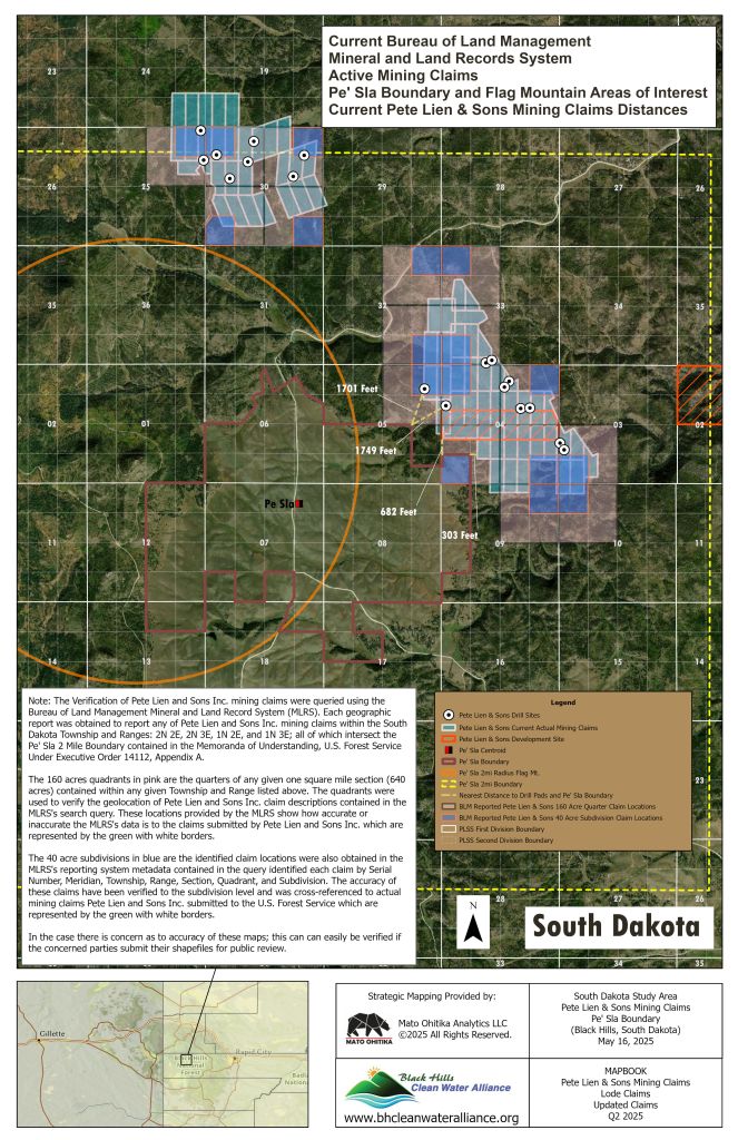

The solid yellow line shows a boundary for Pe’ Sla, a Lakota sacred site that is a critical part of annual observances, as well as being used at other times of the year. This boundary was set in a Memorandum of Understanding between the US Forest Service and tribal representatives in August 2024. The actual area that needs to be protected is substantially larger, as exploratory drilling involves noise, lights, and traffic — usually 24 hours a day. This would disrupt ceremonies, as well as wildlife in the area.
The brown hatching indicates that there are active mining claims in a quarter section of land (1/4 mile by 1/4 mile). The black hatching indicates the quarter sections where Pete Lien & Sons wants to place at least one drilling site. The company proposes 18 drilling sites, with drilling to as much as 1000 feet deep. There would also be 2 storage sites and almost a mile of new 15-foot-wide “overland routes.”
The project would involve 18 drill pads, which could drill vertically and at an angle for up to 1000 feet, and two supply areas. Typically, a drill pad can be the base for up to 10 drill holes. Exploration could contaminate water in the upper Rapid Creek watershed, with some proposed drill pads very close to streams. And there is also the potential for contamination or cross-contamination of underground water sources.
Below are the Forest Service links for this Project.
- For more information about this project including the Plan of Operations click HERE.
- Comment page https://cara.fs2c.usda.gov/Public//CommentInput?Project=67838
- Reading Room page https://cara.fs2c.usda.gov/Public//ReadingRoom?Project=67838
Follow us on Social Media
