Dakota Gold has been very busy in the northern Black Hills in recent years, consolidating ownership or leases on large swaths of privately-controlled land and collecting federal mining claims on a large area of Lawrence County. Note that private ownership of the surface of the land can exist in the same place as federal mining claims are located under the ground.
Their projects stretch from just across the Wyoming line to a few miles west of Sturgis, and from south of Spearfish to just north of Custer Peak.
Black Hills Clean Water Alliance did a little research on Dakota Gold’s activities – very little, as we created the map below from information on the company’s website. There, they list their ten projects in the northern Black Hills, including the projects’ locations. We mapped those locations, and the map shows where the company said each of their projects is located. In short, if you aren’t alarmed, you aren’t paying attention. Their projects stretch from just across the Wyoming line to a few miles west of Sturgis, and from south of Spearfish to just north of Custer Peak.
Note that the company only provided the sections of land where their projects are located, not the specific acreage. So a section of land could be completely controlled by the company, or they could just control a little bit of a section. Another way of thinking about this is that a section is one mile square. So anywhere on this map that is in a colored area could be within a mile of a potential mine site.
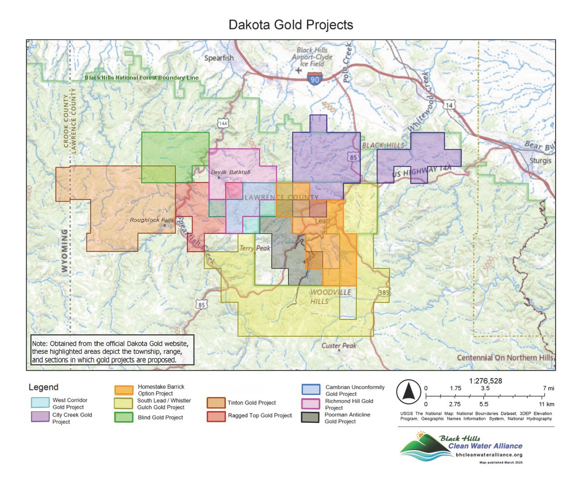
To the south and west of Dakota Gold’s projects, Solitario Resources has two projects, the Ponderosa Project, which just got permission to drill from the Forest Service, and the Golden Crest Project, which includes active drilling. Some of the land that Dakota Gold does not control near Terry Peak would be the Couer Wharf Gold/Silver mine.
If you are a surface landholder in Lawrence County – or thinking of buying property anywhere in the Black Hills — be sure to know the status of any federally-controlled subsurface areas “below the tree roots” at your place. If you do not own your mineral rights, the subsurface could be controlled by a mining company that has claims under your property. The rights of a person/company that holds underground mining claims can overrule the rights of a person who owns the surface of the land. For more information about the 1872 Mining Law click HERE.
Dakota Gold is also planning to mine at Richmond Hill on the east side of Spearfish Canyon in upcoming years — and potentially over to the Maitland area. Water and snow from Richmond Hill drain into Spearfish Creek. Whatever is done at Richmond Hill could impact Spearfish Canyon and the creek north to Spearfish.
There has been mining at Richmond Hill in the past, some of which has been “reclaimed.” But both gold company representatives and the US Forest Service have said that there is no true “reclamation” of this type of mining. A company can attempt to control the contamination coming from an old gold mine site, but these attempts require permanent maintenance to be somewhat effective. In other words, mining is a threat to water not just now, but also for future generations.
We need to prevent new mining in the Black Hills and protect the clean water that we have left! The Black Hills are under attack by mining companies right now. We know that organized and determined public opposition can beat powerful mining interests – in fact, opposition to mining has been successful both historically and recently here. We will not allow the Black Hills to become a sacrifice area for industrial mining companies’ profits!
You have a voice, and you can use it to actively oppose new mining activity in the Black Hills. Now is the time to start! What Can I Do? Click HERE to learn more.
Follow us on Social Media
