
EPA changes clean-up plan at Gilt Edge mine
20 year saga at Gilt Edge
- Tom Griffith Rapid City Journal staff
- Nov 28, 2014 Updated May 20, 2016
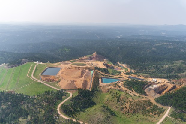
LEAD | To reduce the volume of contaminated water at the former Gilt Edge gold and silver mine in the Northern Black Hills, the Environmental Protection Agency is changing its method for cleaning up the site.
READ MORE AT EPA changes clean-up plan at Gilt Edge mine↗
Take a virtual tour to where you live and see what abandon mine may exist. What waterways are close by?
Courtesy of SkyTruth.org

It’s best to use in full-screen mode to maneuver in the map. Click on arrows icon (right below the + and – signs) in the upper right hand corner of the map.
While headlines across the country point fingers, hundreds of thousands of similar abandoned and inactive mines lie scattered across the nation.
With all the attention on the problem of abandoned and inactive mines we thought we would try to map some of these other mines that haven’t made headlines (yet).
However, “most extensive” is a relative term. According to the Environmental Protection Agency, the United States hosts anywhere from 100,000 to 500,000 abandoned mines , while third party reports from the early 1990’s compiled from state-by-state data put the number at over 557,000. While the USGS data contains plenty of information about the type of minerals once produced by these mines, it says little-to-nothing about who is responsible for the site or the status of site reclamation.
Read more on the SkyTruth Blog Page
The Superfund site in the Northern Hills known as the Gilt Edge was abandon in the late 90s that left “acidic heavy-metal-laden water,” along with tons of waste rock. For 20 years it continues to sit idle while the U.S. Government inches out remediation options. “Historical operations at the site contaminated surface water and groundwater with acidic heavy-metal-laden water. [The] EPA divided the site into three areas, also known as operable units (OUs). OU1 addresses surface contamination. OU2 addresses management and treatment of the acid rock drainage that threatens surface water in the area. OU3 addresses the Ruby Gulch Waste Rock Pile.”
Source: https://cumulis.epa.gov/supercpad/SiteProfiles/index.cfm?fuseaction=second.cleanup&id=0801668#Done
