
We have our work cut out for all of us working to protect water and land in the Black Hills from mining threats. We appreciate you and your continued support of this important work. We will continue to keep you up-to-date. Please follow us here and on our Social Media at:
Contact us if you would like to be included in our email updates and subscribe to our blog in the right panel ——>. And of course, all donations are greatly appreciated. Thank you.
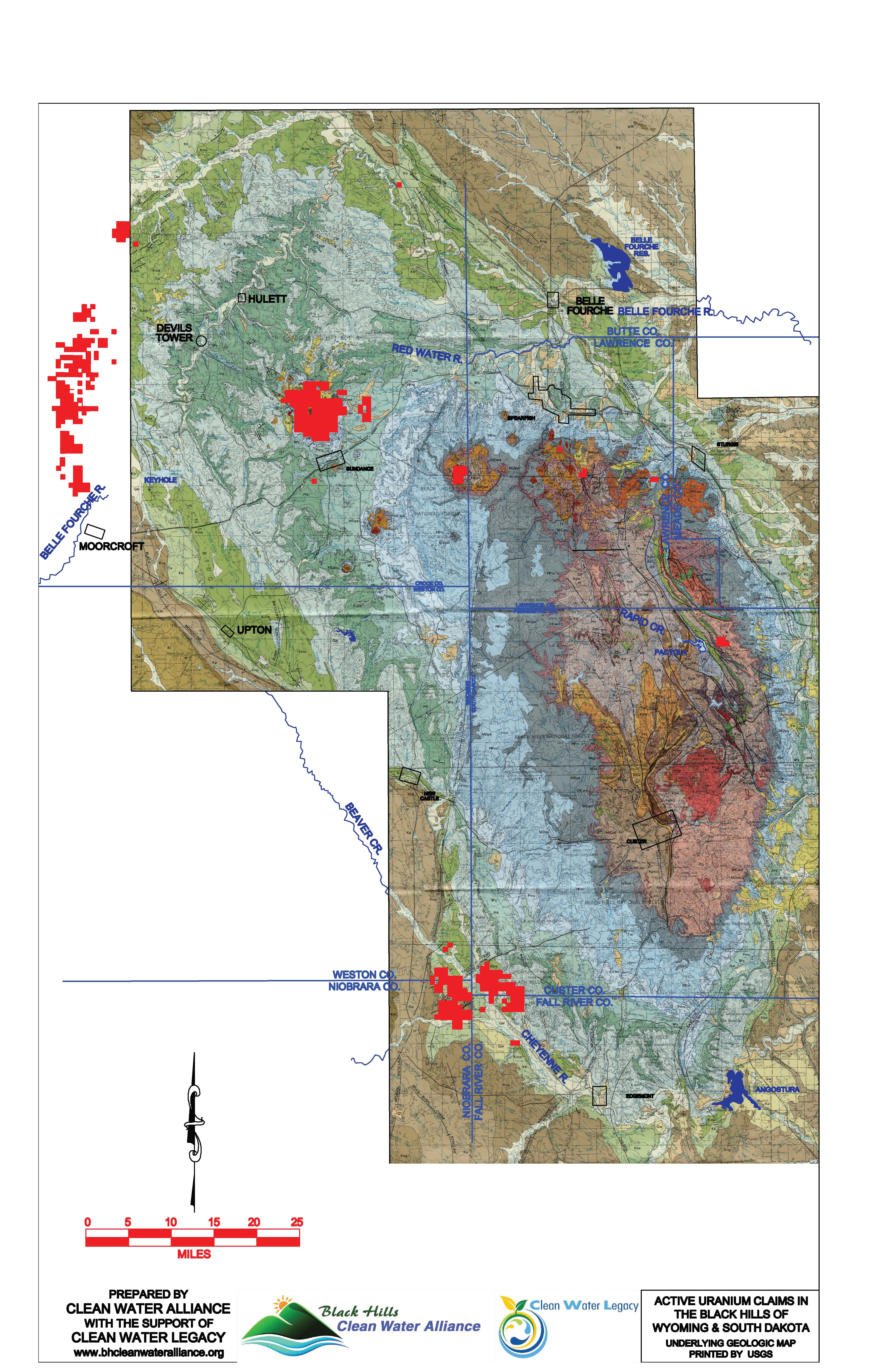
The maps below show active mining claims in the Black Hills according to the Bureau of Land Management records.
Update Posted: October 10, 2025
There are 259,014 acres currently under active mining claims, or about 17% of the entire Black Hills as of September, 2025. This is a bit of a drop since January overall, but all the information indicates that there has been a mix of some claims becoming inactive and some new active claims. The new claims are mostly filling in areas where there were already claims, including some notable growth in the far northwestern part of the Black Hills in Lawrence County, South Dakota. It is also interesting that there are some new claims in the area that’s been of interest for rare earths in Wyoming.

Update Posted: April 25, 2025
This map of the north-central Black Hills shows the threat from Pete Lien & Sons’ proposed graphite exploratory drilling. This is an area southwest of Rochford and north of Deerfield Reservoir. It is directly along Castle Creek tributaries that are in the Rapid Creek watershed, which supplies water for Rapid City, Ellsworth Air Force Base, and communities and ranches downstream.
Click Here to see more details about this map.
The solid yellow line shows a boundary for Pe’ Sla, a Lakota sacred site that is a critical part of annual observances, as well as being used at other times of the year. This boundary was set in a Memorandum of Understanding between the US Forest Service and tribal representatives in August 2024. The actual area that needs to be protected is substantially larger, as exploratory drilling involves noise, lights, and traffic — usually 24 hours a day. This would disrupt ceremonies, as well as wildlife in the area.
The brown hatching indicates that there are active mining claims in a quarter section of land (1/4 mile by 1/4 mile). The black hatching indicates the quarter sections where Pete Lien & Sons wants to place at least one drilling site. The company proposes 18 drilling sites, with drilling to as much as 1000 feet deep. There would also be 2 storage sites and almost a mile of new 15-foot-wide “overland routes.”
Update Posted: Febuary 5, 2025
There is now a new active mining claims map for the Black Hills as of January 2025. It shows about 271,000 acres of claims — about a 3.5% growth from the last map in May 2024. The new claims are located primarily in the far northwestern Black Hills, east of Keystone, and just northeast of the existing Dewey-Burdock uranium claims in Custer County (south of Jewel Cave National Park). The new map also shows that some active claims intrude into the boundaries of Pe’ Sla in the central Hills.

Update Posted: May 20, 2024
This updated map shows about 261,411 acres of active mining claims in the Black Hills for May 2024. There are 1536 fewer mining claims than in early October 2023. So approximately 11% of the October active claims are no longer active mining claims.
Update Posted: Oct. 5, 2023
This Claims Map shows about 293,000 acres of active mining claims in the Black Hills in October 2023. This is more than 20% of the Black Hills!
Update Posted: Apr 27, 2023.
The updated Claims Map now confirms 248,000 acres of active mining claims in the Black Hills as of April 26, 2023.
Update Posted: Jan 10, 2023.
Since our August map update, this one shows that most of the newer active mining claims are the lithium mining claims south of Custer to Pringle. This updated number of mining claims confirms a total of 228,000 acres of active mining claims in the Black Hills as of December 30, 2022. This is about 18% of the total Black Hills — almost one in every five acres in the Black Hills is under a mining claim. That means 228,000 acres are sited for exploration and could potentially become large-scale mining operations that would threaten the water, the land, and human health.
This is the same map as the one above but we have include those companies attached to those claims.
A company or person who has a mining claim and gets the necessary permits may explore for minerals and, if any are found, may mine on the claimed land under the 1872 Mining Law. This 150-year-old law dates from when Ulysses S. Grant was President and says that someone who mines on federally-controlled lands does not have to pay any royalties to the federal government. This outdated law allows water contamination across the western United States. We must protect our limited water from large-scale mining, which uses and contaminates large amounts of water.
202,000 acres of active mining claims in the Black Hills as of August 9, 2022
184,000 acres of active mining claims in the Black Hills as of April 20, 2022
2,100 acres of active mining claims in the Black Hills as of November 7, 2017
Mining Claims Time Line
259,014 acres of active mining claims in the Black Hills as of October 1, 2025.
271,000 acres of active mining claims in the Black Hills as of January 31, 2025
261,411 acres of active mining claims in the Black Hills as of May 20, 2024.
293,000 acres of active mining claims in the Black Hills as of October 2, 2023.
248,000 acres of active mining claims in the Black Hills as of April 26, 2023.
228,000 acres of active mining claims in the Black Hills as of December 30, 2022.
202,000 acres of active mining claims in the Black Hills as of August 9, 2022
184,000 acres of active mining claims in the Black Hills as of April 20, 2022
2,100 acres of active mining claims in the Black Hills as of November 7, 2017
