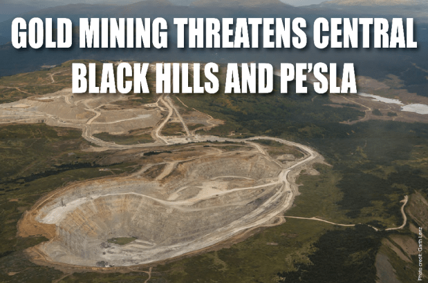
This is what the central Black Hills could look like, if a Canadian company has its way.
There are two exploration efforts underway by Mineral Mountain Resources. One is on private land, and this is the part of the project that the State of South Dakota has given permission to go forward.
The State has given the company an exploration permit and a temporary water permit. This project is now underway, with drilling rig entering the Rochford/Pe’ Sla area.
Following is a list of documents and maps for more information:
TEMPORARY PERMIT TO USE PUBLIC WATERS FOR TESTING PURPOSES
This temporary permit is issued (by the State of South Dakota DENR) with the following qualifications:
Mineral Mountain Resources (SD) Inc. shall notify the Chief Engineer prior to the commencement of pumping from Rapid Creek and the approximate length of time the diversion will be taking place. The amount of water diverted from Rapid Creek shall be metered, the amount recorded and the amount reported monthly to the Chief Engineer. Notification and reporting may be submitted electronically at DENRINTERNET@state.sd.us
Read more… Temporary Water Permit from the state for 1/2/18 to 5/1/18
- The Forest Service’s letter saying they plan to issue a categorical exclusion, which would let the drilling on public lands go forward without an Environmental Impact Statement. FS Letter re Categorical Exclusion 8-14-17
- MMR’s Plan of Operations for the public (Forest Service) lands Plan of Operations – Mineral Mountain
- This 1972 study of gold potential in the area from the US Geological Survey is being used by MMR for their wording to promote the MMR project. A Preliminary Report on the Geology and gold Deposits of the Rockford District
Maps of potential drill sites from Forest Service — these are sites on public lands, not the sites that the company is trying to drill on now
- Topographic map of Forest Service sites

- Topographic map showing potential drill sites on public lands.

- MMR’s claims (area marked in yellow)
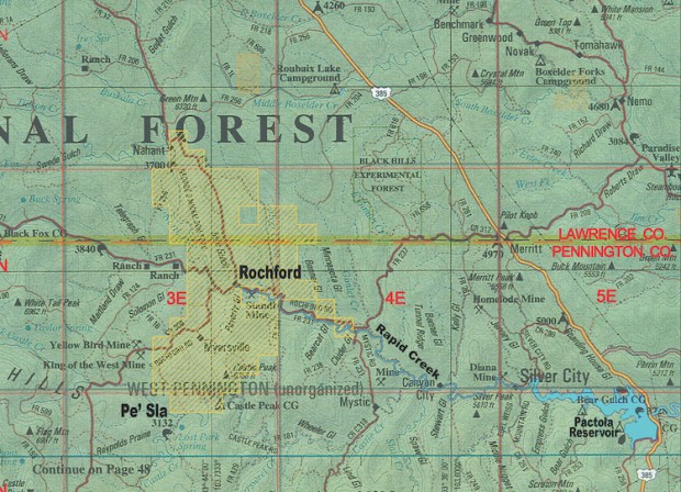
Disclaimer: Maps are based on Bureau of Land Management information, and accuracy is not guaranteed. Mapped down to the quarter section.
Continue to follow us on Facebook for further updates and actions.
